An Introduction to Digital Maps - 10/04/2014
The Ordnance Survey has digitized all of its maps and now makes them available to the public in electronic form. This has given rise to a range of mapping applications for walkers, fell runners, orienteers, cyclists, and anyone who wants to travel. You can look at maps on your PC, laptop, tablet or mobile phone and scroll around without having to unfold or bend your map or get frustrated by finding that what you want is just off the edge of the map. You can plot routes, work out distances and elevations and timings, and use a host of other features. You can then print the section you need, complete with the route you have chosen and marked with your own waypoints and points of interest. You can upload and download routes from your GPS device and even find over 250,000 ready-made routes from other users, the Good Pub Guide and the Country Walking & Trail Magazine. You also avoid carrying larger and sometimes awkward full sized maps that get blown about in the wind or soaked in the rain. It’s also cheaper if you want to plot routes that run across several maps; you don’t need to buy all the maps separately.
In this article Alan Goddard, a prolific walker and enthusiast for long distance walking, describes how he uses digital maps:
I am through and through a map and compass man. With an Ordnance Survey map and a compass and some practice nearly all of us can plan a route and execute it on the ground, so why even consider using digital maps. A digitised map is basically a computer readable version of a paper map. With a digitised map and suitable software you can draw a route on the map and then print it at a convenient size and magnification. I’ll try and illustrate the benefits by planning a simple route.
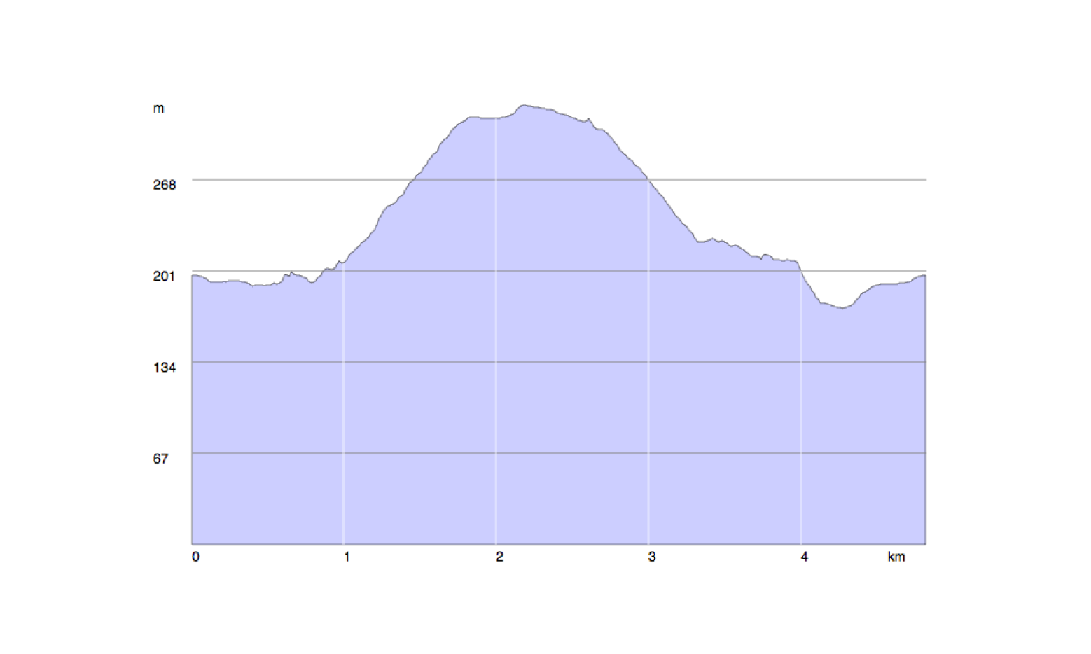
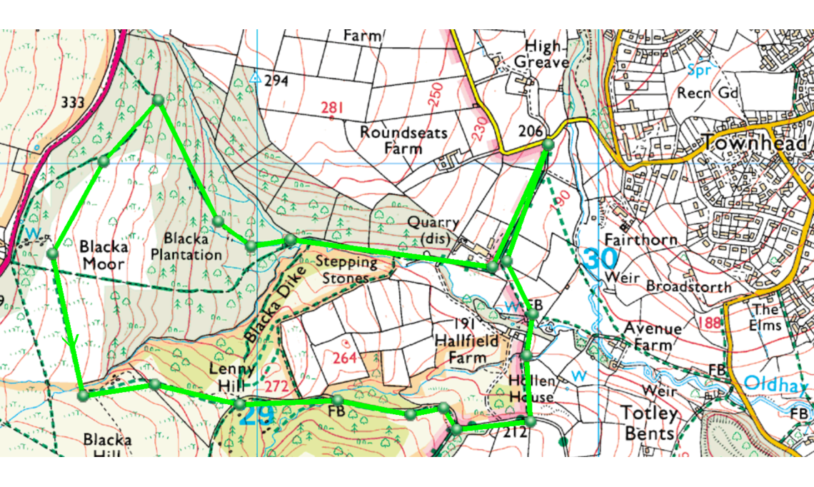
The illustration is of a digitised part of the OS1:25,000 map that covers Blacka Moor. The route (shown in green) starts at the point 206 on the Townhead Road and makes a short circuit of Blacka Moor and returns to the start. Each of the small green circles is called a way point (WP) and the route is planned by putting a series of WPs on the map at turns and junctions on the route. The software stores information about each WP and aggregates this information to create a small database of the overall route. It retains a grid reference for each WP, the total distance covered, the height gained and lost, and an estimate of the time the walk will take. So for our short stroll on Blacka Moor we shall be walking 4.84km with a climb of 187m and it will take us 1hr 16m. The time is based on parameters that we set. In this instance they are 5km per hour (12min per kilometre) plus 10min per 100m climb. We can get a profile of the route showing the climb and descent (see diagram below) and a route card detailing for each WP the distance, climb, bearing and time to the next WP. (The detailed route information is a bit too much for my preference but you take what you want and leave what you don’t want.)
The advantages are self evident. At the planning stage you have an immediate and comprehensive understanding of what you’re in for and you can easily re-plan if the walk is too strenuous or time consuming and vice versa. In addition you can print the route out at size A4 which is ideal for taking with you on the walk. The routes are retained (optionally) within the software so that you have a historical record of all the walks that you have enjoyed.
Convinced? Well why not test it for yourself. The supplier that I use is Anquet Technology; website:www.anquet.com. There are other suppliers: Memory Map, Fugawi and Tracklogs for example, but certainly I have found Anquet a technologically far sighted and very customer friendly supplier. The basic software is free to download to both pc and mac (via the app store) hardware. With the download you get sample maps which provide the opportunity to play around and see if you are attracted to the system. (NOTE: If you’re a Mac user, as I am, the supporting software is currently being rewritten. Beta testing software is available but the full solution is some months away.)
The cost comes in the purchase of the maps and here you can spend as much or as little as you want. The OS 1:50,000 series is relatively inexpensive to buy, the 1:25,000 somewhat more. As an example I recently bought the 1:25,000 maps covering the Ridgeway National Trail (As well as normal OS Maps Anquet supply purpose designed maps of the National Trails and National Parks) for £14.50. Coverage of the the Peak District at 1:25,000 is £22.50. Anquet also frequently have offers with selected maps at a significant discount.
Of course none of this touches on the wider use of technology in route finding. Map and compass are excellent tools but occasionally even the best of us gets lost. GPS can provide a valuable secondary support by pinpointing exactly where on the map you are. In this article I’m not going into currently available commercial hand held GPS based solutions but they are out there (two of the leading suppliers are Garmin and Magellan). However, much more accessible modern smart phones provide a readily available GPS-based solution. Anquet provides software for both iPhones and Android smart phones. These can be operated both independently or in conjunction with your computer. Used independently the maps are easy to use and your position on them is clear from a GPS locator shown on the screen. Used in conjunction with your mac or pc your route will also be displayed. I’m still a paper map and compass man when I’m out walking but really have found that the benefits of modern technology have improved my own experience quite markedly. Why not give it a go?
Alan Goddard
Footnote - If you have suggestions for articles in this series please let me know.
Keith Shaw, Assistant Editor
keith.shaw@dorevillage.co.uk